end of header
History
You are here: Census.gov › History › Programs › Geography › Regions and Divisions
Geography
Regions and Divisions
The partition of the geographic regions of the United States goes back to the colonial period of American history. By the 18th century, New England, the Middle Atlantic, and the South were agreed to be the major sections of the Atlantic seaboard. These colonial groupings were the forerunners of the regional combinations that later appeared in census publications. In fact, the area called New England in colonial times has maintained its geographic identity to the present day.
At that time, there were other regional designations that appeared in the geographic structure of later censuses; area names such as tidewater, coastal plain, piedmont, and the backcountry were known and in general use even before the American Revolution.

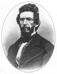
James D.B. DeBow
At first, census data was not broken down by region. In fact, regional designations were not used until James D.B. DeBow, a journalist and statistician, became director of the census in 1853. His compendium volume of census reports presented an extensive array of socioeconomic information within five great regions: New England, Middle, Southern, Northwestern, and Southwestern. This compendium also featured the first map to appear in a census publication. It divided the United States into four regions, which were based on major drainage systems.
After completing the publication of the 1850 census data, DeBow reclassified his regional designations. He divided the country into three great sections: the East, West and Interior. These sections were subdivided into northern and southern subsections. In effect, DeBow's new system used the three largest of the four drainage systems he had identified on his earlier map as the basis for the great sections of the country. This time, however, the sections were divided based on state and territorial lines.
Various reports from the 1850 and 1860 censuses used other regional designations. Land area, population, and density tables reported data for seven regional groupings: New England, Middle, Central Slave, Coast Planting, Texas, Northwestern, and California. Summary tables for the 1860 census reported data for New England, Middle, Southern, Western, and Pacific regions. "Great Natural Divisions" were used to report mortality statistics in the 1850s and 1860s; these divisions were: Northeastern States, Lowlands of the Atlantic Coast, Intermediate Region, Allegheny Region, Lower Mississippi Valley, Northwestern States, and Pacific Coast. These divisions comprised either groupings of states or groupings of counties.
The results of the 1870 census did not expand upon DeBow's system. The United States, however, was beginning to grow into its territory; by 1880, except for the eventual consolidation of Oklahoma and the division of Dakota Territory, the boundaries of the states and territories resembled those of the contiguous 48 states today. Henry Gannett, geographer of the Census Office during the 1880's, suggested a new regional division scheme for the 1880 census. Gannett, in a plan that bore a strong resemblance to DeBow's 1860 design, grouped the states into three great divisions: Atlantic, Great Valley, and Western. These divisions were then sub-divided into three smaller regions, as well.

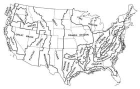
View larger image
The 19 topographical regions of the United States
following the 1900 census.
This new style of regional delineation made it difficult to compare the topographical region results of the 1900 census with past surveys. Because of this, Henry Gannett adjusted the topographical division boundaries to correspond with county lines. To this day, the Census Bureau's regions and divisions correspond to the political units for which the information is otherwise collected. This not only simplifies census data processing, but also makes it easier to compare data across time.
The delineations drawn by Gannett for the 1880 census were used, with only minor modifications, as basic regional divisions for census data through the 1990 census.
The nine regional divisions as presently constituted, except for Alaska and Hawaii, first appeared in the population report of the 1910 decennial census. The 1910 agricultural census used a similar arrangement, as did the 1920 decennial census.
The 1930 population and agriculture census publications also used nine geographic divisions; however, the population census omitted summarizing data for the three great sections, as well as the designation of areas as east and west of the Mississippi River.
The 1940 population and housing census reports revived these three areas; they also continued to present statistics for the nine divisions. The 1950 census publications presented summaries for the same nine geographic divisions in use since 1910. The 1960 census saw the addition of Alaska and Hawaii to the Pacific Division; the 1970 and 1980 census publications brought no further changes. Except for the 1984 renaming of the North Central Region as Midwest, the Census Bureau continued the same system of geographic units for the 1990 and 2000 census publications.
Comments or suggestions?


