
Official websites use .gov
A .gov website belongs to an official government organization in the United States.
Secure .gov websites use HTTPS
A lock (
) or https:// means you’ve safely connected to the .gov website. Share sensitive information only on official, secure websites.

Topics
Data & Maps
Surveys & Programs
Resource Library
USPS City Versus Census Geography
USPS City Versus Census Geography
The U.S. Census Bureau relies on an accurate postal address and the U.S. Postal Service (USPS) to deliver census correspondence to most households. A postal address typically is composed of house number, street, city, state, and ZIP CodeTM. The mailing address for a residence is not used to assign housing units to the proper political jurisdiction or census geography. Instead, the Census Bureau uses the physical location of a housing unit to assign it to the proper geographic areas. The Census Bureau recognizes that the Post Office “city” name associated with a particular ZIP Code in the mailing address for a residence may differ from the legal municipality or district in which the housing unit is actually located. In addition, the “city” name(s) used by the USPS to identify a specific ZIP Code or Post Office may not be the name that residents serviced by the Post Office consider themselves to reside in.
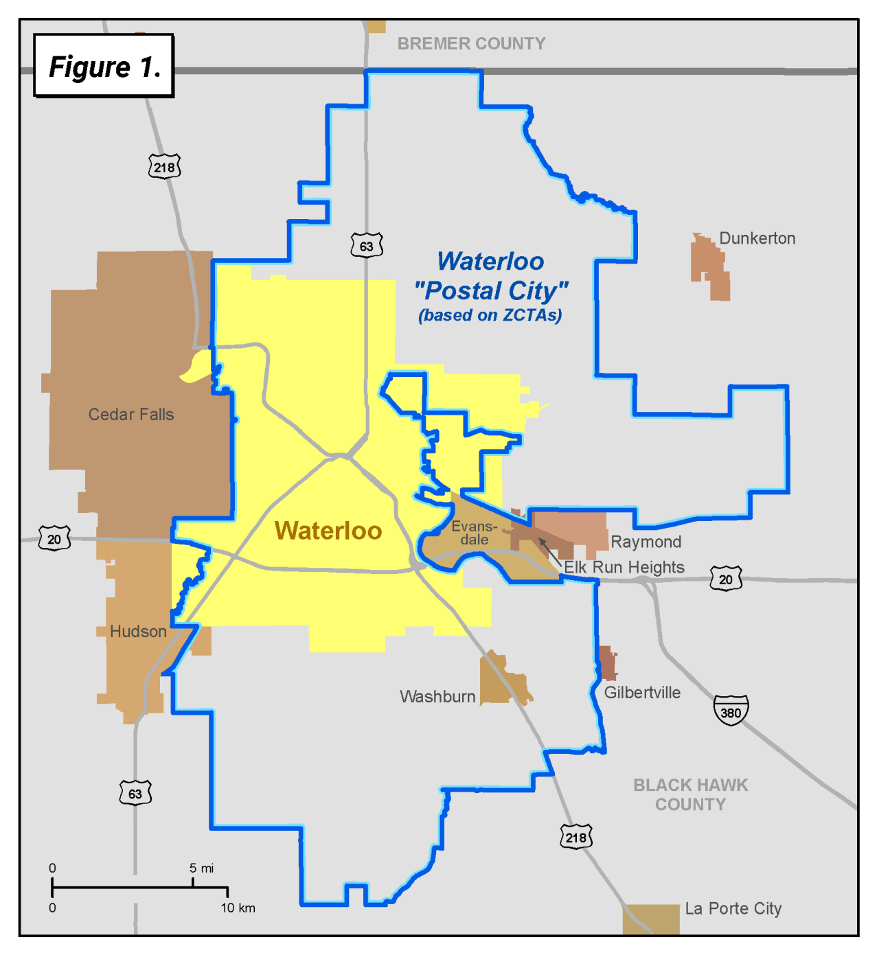
Figure 1 above illustrates the approximate area (using aggregations of Census Bureau-defined ZIP Code Tabulation Areas (ZCTAs)) of the Waterloo “postal city” based on the USPS’s preferred or recommended city name for that ZIP Code. This area includes most, but not all, of the legal boundaries of Waterloo city, and parts of Elk Run Heights city and Hudson city. In addition, this “postal city” includes area that is part of unincorporated Black Hawk County, including Washburn census designated place (CDP). Addresses in this area have “Waterloo” as the preferred city in their mailing address.
Figure 2 below shows the three ZCTAs (50701, 50702, and 50703) that comprise the Waterloo "postal city." Although each of these ZIP Codes has a “Waterloo” mailing address, they do not follow legal city boundaries and frequently extend beyond the actual city limits of Waterloo. Census data are tabulated to the jurisdiction where the housing unit is physically located, not based on the city name used for the mailing address. For example, a housing unit located in Washburn CDP with a “50702” ZIP Code is included in the census data for Washburn CDP, not Waterloo city.

The USPS provides the Census Bureau with a data file, the City State Product, which identifies the preferred or recommended city name associated with each ZIP Code. Figure 3 below shows a section of the City State Product with the ZIP Codes and the preferred or recommended city name highlighted for the ZIP Codes shown in the map above.

The Census Bureau built and verified its address list for the 2020 Census using advanced technology, strong partnerships with tribal, state, and local governments, federal agencies like the U.S. Postal Service, and carefully managed census operations. During in-office and in-field census operations, housing unit locations were identified, verified, and assigned to a series of precise geographic codes, together called a “geocode,” using geospatial technologies. This geocode includes the census block and surrounding geography, including the municipality, tribal, or county code as appropriate. Data that result from the 2020 Census are tabulated using these geocode assignments for each household, not the "postal city" name in the mailing address assigned to the household. Therefore, each census tract, voting district, school district, tribal area, county, municipality, and other geographic area receives accurate results from the census.
In addition, the Census Bureau provided tribal, state, and local governments an opportunity to review and provide feedback on the address list we developed for their community through the 2020 Local Update of Census Addresses, or LUCA Program. Participating tribal, state, and local officials verified that the Census Bureau accurately coded each address on the list to the correct and authoritative geographic codes, regardless of the “postal city” name used by the USPS for delivering mail.
The USPS has ZIP Code lookup tools available at https://tools.usps.com/go/ZipLookupAction_input.
Page Last Revised - October 8, 2021
✕
Is this page helpful?
 Yes
Yes
 No
No
 Yes
Yes
 No
No✕
NO THANKS
255 characters maximum
 255 characters maximum reached
✕
Thank you for your feedback.
Comments or suggestions?

Comments or suggestions?