
Official websites use .gov
A .gov website belongs to an official government organization in the United States.
Secure .gov websites use HTTPS
A lock (
) or https:// means you’ve safely connected to the .gov website. Share sensitive information only on official, secure websites.

Topics
Data & Maps
Surveys & Programs
Resource Library

Iowa 175th Anniversary of Statehood (1846): December 28, 2021
Press Release Number CB21-SFS.167

From the Guide to 2010 State and Local Census Geography – Iowa – History:
The United States acquired the area of Iowa from France in 1803 as part of the Louisiana Purchase. Iowa Territory was organized on June 12, 1838, from part of Wisconsin Territory; it included all of present-day Iowa, the eastern part of North Dakota and South Dakota, and the western part of Minnesota. Iowa was admitted to the Union on December 28, 1846, as the 29th state with generally the same boundary as the present state. The remaining part of the territory was unattached until the organization of Minnesota Territory in 1849. Nebraska and Iowa have made periodic adjustments to their boundary as the Missouri River has changed its course.
Census data for Iowa are available beginning with the 1840 census. The 1840 population includes the portion of Iowa Territory in present-day Minnesota west of the Mississippi River and a line drawn from its source northward to the Canadian boundary.
Key Stats
From QuickFacts: statistics for all states and counties, and for cities and towns with a population of 5,000 or more.


Note: The dashboard shown above is cropped at the bottom. Click on the image to see the full dashboard.
More Stats
From data.census.gov:

Note: The profile shown above is cropped at the bottom. Click on the image to see the full Profile.

Source: U.S. Census Bureau, Population Division (Annual Estimates of the Resident Population).

Source: 2019 American Community Survey (ACS) 1-Year Estimates.
Source: Business Formation Statistics (BFS).
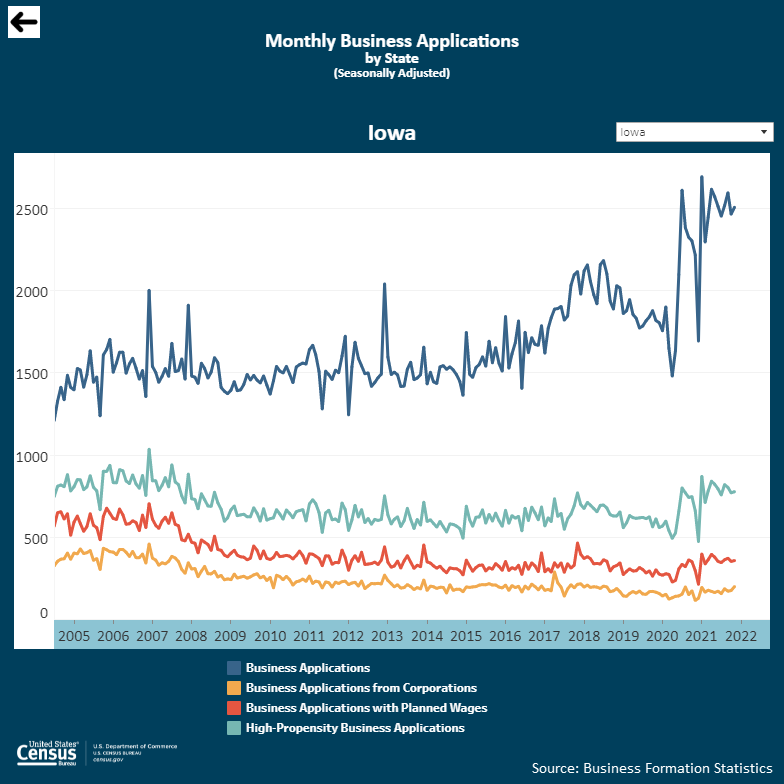
Note: Click on the image above to go to the BFS data page. To see the Iowa graphic, scroll down to Interactive Graphs, By State. Click on the icon for Monthly Business Applications by State (BA) and select Iowa in the upper right drop-down area.
From Foreign Trade > U.S. International Trade Data:
Note: After you create an account, you can choose between State Export Data (Origin of Movement) or State Import Data (State of Destination) by Harmonized System (HS) or NAICS. For more information, see the Quick Start Guide.
Source: Monthly State Retail Sales (Select Iowa)
From the State Data Center (SDC) Program:
From Census Bureau History:

From the Statistics in Schools (SIS) program:

Note: The Iowa page is cropped at the bottom. Click on the image above to go to the State Facts for Students main page. Then use the drop down to select Iowa or click “IA” on the map to see the full page for Iowa.
Page Last Revised - December 23, 2021
✕
Is this page helpful?
 Yes
Yes
 No
No
 Yes
Yes
 No
No✕
NO THANKS
255 characters maximum
 255 characters maximum reached
✕
Thank you for your feedback.
Comments or suggestions?

Comments or suggestions?