120th Congress Block Equivalency Files
120th Congress Block Equivalency Files
Download the 120th Congressional District Block Equivalency Files
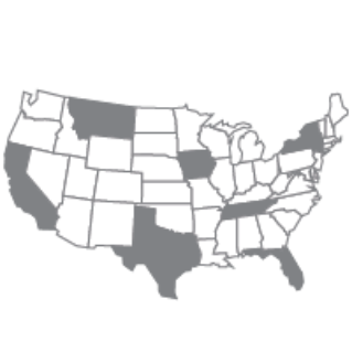
These Block Equivalency Files (BEFs) are the whole 2020 Census tabulation block representations of the 120th Congressional District plans as submitted by the states to the U.S. Census Bureau.* The .ZIP file contains a national block equivalency file and individual state files for the nine states (Alabama, California, Florida, Louisiana, North Carolina, Ohio, Tennessee, Texas, and Utah) that redrew their congressional district plans for the 120th Congress. The fields in these files should be imported as text to preserve leading zeros.
In instances where plans included split 2020 Census tabulation blocks, the Census Bureau requested that the state assign the whole block to one district for the purpose of tabulating data. These block equivalency files contain the whole block tabulation plan.
Only one state--Colorado--split blocks in their 120th Congressional District plan. Colorado split one block, 080010096072000, between Congressional District 07 and Congressional District 08. The data for that census block will be tabulated to Congressional District 08. This is unchanged from Colorado's 118th and 119th Congressional District plan.
*IMPORTANT NOTE: On September 23, 2026, the U.S. Supreme Court declined to allow Missouri to use a new congressional map for the 2026 elections that had been created under House Bill 1 of the 103rd General Assembly’s 2nd Extraordinary Session and signed by the Governor in September 2025. This paused an order from a federal appeals court directing the state to use the new map. Prior to this decision, the U.S. Census Bureau had collected the new congressional map from the state and generated some products based on that new plan. These products will be regenerated to reflect the plan now in effect for the 2026 congressional elections, which is the same plan that was used in the 2022 and 2024 elections.
The national 120th Congressional District Block Equivalency File was regenerated on October 7, 2026 to reflect the MIssouri plan that will be used in the 2026 congressional elections. The individual state block equivalency file for Missouri reflecting the new map was also removed from the ZIP file. The Missouri plan now remains unchanged from the plans used in the 2022 and 2024 elections.


Notes
1) The block equivalency files are based on the original 2020 Census tabulation blocks as they appeared in the official 2020 Census Data Products. If you are working with geographic data created after the 2020 Census—such as shapefiles, GeoDatabases, or online viewers like TIGERWeb—you may notice slight differences between the blocks shown in these products and those from the original 2020 Census products (and used to create these BEFs).
These differences occur when block boundaries were updated after 2020 for greater spatial accuracy. For example, if a block boundary follows a road or the edge of an incorporated place, and that road or boundary is adjusted to better match real-world features, the block boundary will change as well. The blocks released with the 2020 Census reflect their original shapes, and jurisdictions their 2020 boundaries, while blocks and jurisdictions in post-2020 products (also known as “current blocks” or "current geography") show any updates made since then.
2) Congressional districts are identified by a 2‐character numeric FIPS code. Congressional districts are numbered uniquely within state. The District of Columbia and Puerto Rico have the code of 98, which identifies their status with respect to representation in Congress:
- 01 to 53—Congressional district codes
- 00—At large (single district for state)
- 98—Nonvoting delegate
3) In Connecticut, Illinois, and New Hampshire the state did not assign the current congressional districts to cover all of the state or equivalent area. The code “ZZ” has been assigned to areas with no congressional district defined (usually large water bodies). These unassigned areas are treated within state as a single congressional district for purposes of data presentation.
Related Information