2024 Geography Changes
ACS Documented Changes
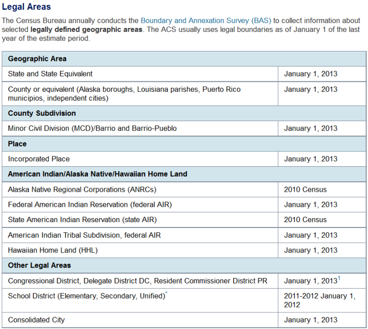
Each year some new entities come into existence and other entities are dissolved. This may be the result of new incorporations or statistical delineations, the redrawing or splitting of administrative areas, disincorporations, mergers and consolidations, and other types of changes. Below is a link to the geographic changes that have occurred over the last year and are relevant to ACS data:

Boundary Changes
Some areas of the nation may have reduced comparability, or non-comparability from one year to the next. Changes can happen for a variety of reasons including updates to tribal geography, annexation, legislative redistricting, geocoding updates, etc.
For those entities that experienced changes, making comparisons between an entity in its previous form to its current form should be done cautiously and with good understanding that the entity may be substantially different. TIGER Line Shapefile products are one tool used to perform detailed comparisons of the inventory and boundaries of geographic areas, by year. Information about these files and links to the mapping files themselves can be found at: TIGER Data Products Guide. Reference files for change can be located here: Relationship Files.
Release of 119th Congressional Districts
The Census Bureau collected the 119th Congressional District (CD) boundaries for the 2024 election cycle. Five states (Alabama, Georgia, Louisiana, New York, and North Carolina) delineated new congressional district boundaries for the 2024 election cycle. All other states, the District of Columbia, and Puerto Rico had no changes to their congressional district (CD) boundaries from the 2022 cycle. For more information see: Redistricting Data Program Congressional Districts.
Release of 2024 State Legislative Districts
The Census Bureau collected the 2024 State Legislative District boundaries for the 2024 election cycle. Eight states (Georgia, Minnesota, Montana, North Carolina, North Dakota, Ohio, Washington, and Wisconsin) delineated new state legislative district-upper (SLDU) chamber plans for the 2024 election cycle. Eleven states (Georgia, Michigan, Minnesota, Montana, New York, North Carolina, North Dakota, Ohio, South Carolina, Washington, and Wisconsin) delineated new state legislative district-lower (SLDL) chamber plans for the 2024 election cycle. A new SLDU plan was approved for Michigan after the Census Bureau collected these boundaries but still prior to the 2024 elections. The Michigan Senate (upper) chamber is not up for reelection until 2026, so that plan is not reflected in the geographic and data products below. It will instead be captured in our 2026 collection cycle. All other states, the District of Columbia, and Puerto Rico had no changes to their state legislative district (SLD) boundaries from the 2022 cycle. For more information see: Redistricting Data Program State Legislative Districts.
Related Information