
Every State Declared Federal Disaster Areas During COVID-19 but Other Natural Disasters Are Happening
For the first time in history, all 50 states were declared federal disaster areas due to COVID-19. At the same time, hurricanes, floods, wildfires and winter storms continued to hit communities already dealing with the pandemic.
Communities were overwhelmed and so was the U.S. Census Bureau’s award-winning OnTheMap for Emergency Management data tool.
As each state becomes a disaster or emergency declaration area, real-time data on hurricanes, floods, wildfires, and winter storms were updated but drowned out by the nationwide swath of COVID-19 disaster areas.
As each state becomes a disaster or emergency declaration area, real-time data on hurricanes, floods, wildfires, and winter storms were updated but drowned out by the nationwide swath of COVID-19 disaster areas.
In order to show national weather events, we had to redesign the OnTheMap for Emergency Management tool.
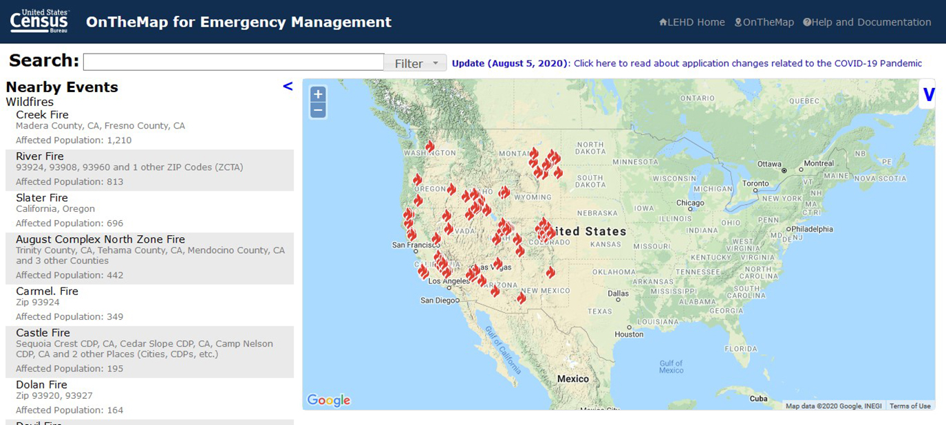
We organized and grouped each natural disaster by individual threat and clearly displayed them on the map to help users identify and focus on specific events other than COVID-19.
The bright orange shading identifying Disaster Declarations transitioned into an opaque orange providing a starker backdrop for all emergency events. Now, users can choose events they are interested in by using the legend and map controls to the right of the map. (See below.)
“Everything has changed,” said George “Chip” Walker, specialist assistant and co-chair of the Emergency Preparedness and Response Team. “Response teams have had to anticipate challenges due to the pandemic and adapt recovery operations.”

Helping Guide Emergency Management
When crises and emergencies happen, OnTheMap for Emergency Management helps decision makers plan, respond and launch recovery activities by providing timely access to detailed information about affected workforces and populations.
The information comes a mix of data from the Census Bureau and other federal agencies such as the Department of Agriculture, Department of Interior, the Federal Emergency Management Agency (FEMA), and the National Oceanic Atmospheric Administration (NOAA).
Disaster declaration areas defined by FEMA include states, territories and tribal areas eligible for public and individual assistance.

OnTheMap for Emergency Management can help users identify areas affected by a disaster and identify social, physical and economic vulnerabilities. Users can pinpoint affected populations, and housing, and the impact on the workforce and industries.
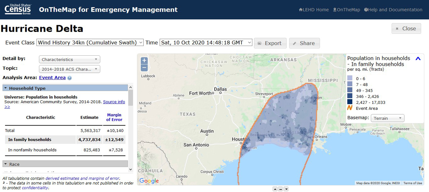
Updates arrived just in time, Walker said, noting that “2020 has proven to be a historic active hurricane season.”
The hurricane season had been predicted to be very active and in August, the NOAA increased the number of named storms from 19 to 25. The average season usually has 12 storms.
Changes to the data tool were made just before the season’s 25th named storm, Hurricane Delta, and the hurricane season does not officially end until Nov. 30.
This has been a record-breaking year for many things, including hurricanes and wildfires.
2020 is also facing the potential of an above normal fire season in California, Oregon, Colorado and other U.S. states. As of Oct. 19, 2020, there had been 46, 148 wildfires compared to 42,821 wildfires the previous year, with about 8.3 million acres burned.
OnTheMap for Emergency Management provides a link to the FEMA page that lists resources for financial assistance and information on areas under disaster declarations.

Related Statistics
-
Stats for StoriesNational Preparedness Month: September 2025Find resources on wildfires, air quality, hurricanes, extreme heat, tornadoes, floods, pandemics and more at census.gov/disasters.
-
Stats for StoriesRed Cross Month: March 2024The U.S. Census Bureau produces timely local data critical to Emergency Management about mitigation, preparedness, response and recovery efforts.
Subscribe
Our email newsletter is sent out on the day we publish a story. Get an alert directly in your inbox to read, share and blog about our newest stories.
Contact our Public Information Office for media inquiries or interviews.
-
America Counts StoryHow Census Data Help the Nation Respond to DisastersApril 09, 2020In a Community Risk Reduction Radio podcast, the Census Emergency Preparedness and Response Team shows how Census data help when any disaster strikes.
-
America Counts StoryKey Player in Disaster Response: The U.S. Census BureauOctober 15, 2019Community planners rely on census statistics to prepare evacuation plans and supply distribution after natural disasters and...
-
America Counts StoryA Look at Businesses in Coastline Counties During Hurricane SeasonJuly 15, 2020Population growth in areas most vulnerable to hurricanes is of concern to emergency managers but so are the 2.4 million businesses in coastline areas.
-
Business and EconomyA Road Trip Across the Vacation EconomyJuly 14, 2026The Census Bureau rings in the summer with a travel statistics road map.
-
HealthWhere You Live Matters for Your Health and So Does How We Measure ItJuly 09, 2026Census Bureau research helps policymakers and researchers identify the most reliable ways to predict health outcomes and distribute resources accordingly.
-
PopulationU.S. Fertility Continues to Drop but Still High in Some CountiesJune 25, 2026Counties with the highest numbers of births have some of the lowest fertility rates.
-
TaxationFundamental Shifts in State Taxes in Past CenturyJune 17, 2026Income and sales taxes have largely replaced property taxes, once the lion’s share of state tax revenue.